You are using an out of date browser. It may not display this or other websites correctly.
You should upgrade or use an alternative browser.
You should upgrade or use an alternative browser.
Pacific Crest Trail
- Thread starter mozey
- Start date
Snoopdogg
Long Time Member
- Messages
- 3,183
Mozey, be careful.

 nypost.com
Hiker’s legs went totally numb on a mountain hike — and the surprise culprit is remarkably common
The woman felt a sting that she thought was a spider bite.
Rie bread
Very Active Member
- Messages
- 1,204
Man walker is a bit of a bust but walker burger might be open! There was a “coffee shop” a few years ago no idea if it’s in business. Going west used to have lots to offer but the fire wrecked it. Maybe Kennedy meadows is open? I’ll check for you!
Edit: They are open but I can’t figure out if they serve breakfast! It’s a damn good place and great people!
Grover hot spring! If you can make it there for a zero day rest those bones!
Your In my home stretch of the Sierra and I am incredibly home sick at the moment lol!
Edit: They are open but I can’t figure out if they serve breakfast! It’s a damn good place and great people!
Grover hot spring! If you can make it there for a zero day rest those bones!
Your In my home stretch of the Sierra and I am incredibly home sick at the moment lol!
Last edited:
Homer
Long Time Member
- Messages
- 14,477
I think we've talked about this before Riebread......but he's a full 200 miles past the Kennedy Meadows I'm familiar with......Man walker is a bit of a bust but walker burger might be open! There was a “coffee shop” a few years ago no idea if it’s in business. Going west used to have lots to offer but the fire wrecked it. Maybe Kennedy meadows is open? I’ll check for you!
Edit: They are open but I can’t figure out if they serve breakfast! It’s a damn good place and great people!
Grover hot spring! If you can make it there for a zero day rest those bones!
Your In my home stretch of the Sierra and I am incredibly home sick at the moment lol!
Rie bread
Very Active Member
- Messages
- 1,204
West side 108I think we've talked about this before Riebread......but he's a full 200 miles past the Kennedy Meadows I'm familiar with......
Mozey highway 89 is closer to Grover hot spring!
Homer
Long Time Member
- Messages
- 14,477
Yes......My Kennedy meadows is just north of walker pass.....Hwy 178West side 108
Mozey highway 89 is closer to Grover hot spring!
Rie bread
Very Active Member
- Messages
- 1,204
I find it fitting on both sides of the Sierra is a Kennedy meadows. Neat place definitely worth a stop if your north of bishopYes......My Kennedy meadows is just north of walker pass.....Hwy 178
eelgrass
Long Time Member
- Messages
- 31,741
I've been stung by stinging nettles many times. It's definitely a weird sensation. Once you realize what it is it's no big deal.Mozey, be careful.
Hiker’s legs went totally numb on a mountain hike — and the surprise culprit is remarkably common
The woman felt a sting that she thought was a spider bite.
LivingTheDream
Active Member
- Messages
- 540
There is a Kennedy Meadows South and a Kennext Meadows North. The KMN is an option, but my app is giving higher hiker reviews for the motel in Walker, so that's why I'm heading there.
Are you using FarOut? Or is there another app that you would recommend.
Homer
Long Time Member
- Messages
- 14,477
Did it ever cause you to call S&R?I've been stung by stinging nettles many times. It's definitely a weird sensation. Once you realize what it is it's no big deal.
mozey
Long Time Member
- Messages
- 3,157
Yes I'm using FarOut. I do recommend it if you're thinking about hiking one of the long distance trails.Are you using FarOut? Or is there another app that you would recommend.
eelgrass
Long Time Member
- Messages
- 31,741
No, but one time my wife was picking blackberries and I thought she was going to.Did it ever cause you to call S&R?

mozey
Long Time Member
- Messages
- 3,157
Didn't have any luck trying to hitch to Walker, but a guy who's supporting his wife on the PCT offered me a ride to Kennedy Meadows North, so that's where I ended up.Man walker is a bit of a bust but walker burger might be open! There was a “coffee shop” a few years ago no idea if it’s in business. Going west used to have lots to offer but the fire wrecked it. Maybe Kennedy meadows is open? I’ll check for you!
Edit: They are open but I can’t figure out if they serve breakfast! It’s a damn good place and great people!
Grover hot spring! If you can make it there for a zero day rest those bones!
Your In my home stretch of the Sierra and I am incredibly home sick at the moment lol!
mozey
Long Time Member
- Messages
- 3,157
Mammoth to Kennedy Meadows North: I keep hoping the trail will flatten out just a little bit but so far it's not really cooperating. From Mammoth, the trail took me through the Ansel Adams, Yosemite, and Emigrant Wilderness Areas, and I've lost count of how many passes I've gone over. Still hiking a lot in snow, but at least for this stretch I did not have to ford any sketchy rivers. The last couple days I've been hiking with a couple women that had already teamed up a couple weeks ago for the Sierras. They are definitely an odd couple, one being from Taiwan and the other from the Netherlands, one being dark and less than 5' tall and the other being light and over 6' tall. Throw me into this mix and we make quite the oddball group. It's interesting to me how thru
-hiking builds camaraderie in people with such diverse backgrounds.


-hiking builds camaraderie in people with such diverse backgrounds.
mozey
Long Time Member
- Messages
- 3,157
That was the second one that I had to detour around, but unlike the first one this was an easy detour.That's an interesting bridge. Yikes! Just because someone sets a trap doesn't mean you have to step in it.
Last edited:
elkassassin
Long Time Member
- Messages
- 38,416
Hey mozey?
Did Y'all Sleep In The Same Tent To Stay Warm?
(((RAZZIN Ya!)))
Did Y'all Sleep In The Same Tent To Stay Warm?
(((RAZZIN Ya!
)))mozey
Long Time Member
- Messages
- 3,157
First, I'm happily married, and hope to stay that way, so nothing like that is going on with me. Also, I snore like a bear, so I try to do everyone else a favor by keeping out of their earshot...Hey mozey?
Did Y'all Sleep In The Same Tent To Stay Warm?
(((RAZZIN Ya!

elkassassin
Long Time Member
- Messages
- 38,416
You Know I'm RAZZIN Ya mozey!
Stay Safe Out There!
Stay Safe Out There!
First, I'm happily married, and hope to stay that way, so nothing like that is going on with me. Also, I snore like a bear, so I try to do everyone else a favor by keeping out of their earshot...
elkassassin
Long Time Member
- Messages
- 38,416
eelgrass
Long Time Member
- Messages
- 31,741
The one less than 5' would fit in Homer's backpack.The One Less than 5' Doesn't Interest You Huh?
mod700
Active Member
- Messages
- 385
Damn impressive, thanks for taking us along!, ran across a guy last year on the pct, up by Humboldt summit, guy was looking bad, he had gotten girdia 3 days earlier...was going to pick him up when I came back over the top, and get him down to town, but some other guys gave him a ride. Be safe man, give a holler if you need anything when you get up towards hwy 70 to hwy 36 country.
DeerMadness
Long Time Member
- Messages
- 5,588
The term for less than 5' is fun-size.The one less than 5' would fit in Homer's backpack.
elkassassin
Long Time Member
- Messages
- 38,416
Don't Let Homer BS You!
He's Always Liked A Chick That Can Stare Him Right In The Pecker!
He's Always Liked A Chick That Can Stare Him Right In The Pecker!
mozey
Long Time Member
- Messages
- 3,157
Kennedy Meadows North to South Lake Tahoe. For a moment there I thought I was back in the desert. Trail is finally starting to flatten out a little, but still dealing with some snow at elevations above 8,000 feet. But miles per day are starting to creep back up. I did a 26 two days ago followed by a 27 yesterday. I was tempted last night to go for 33 to get to the paved road, but I knew my odds of getting a hitch after dark were probably zero, so I opted to camp up on the mountain and leave six for this morning.
Mosquitoes are starting to become an issue. Have to spray myself down if I want any peace when ever I stop for a break.
I'm 1,090 miles in.


Mosquitoes are starting to become an issue. Have to spray myself down if I want any peace when ever I stop for a break.
I'm 1,090 miles in.
mozey
Long Time Member
- Messages
- 3,157
Lots of section hikers doing southbound (we call them SOBOs as opposed to us NOBOs). But I haven't met any SOBOs yet that are doing the entire PCT.Great pictures Moz. The lakes certain enhance the environment and beauty.
Have you encountered any hikers making the trip north to south yet?
Rie bread
Very Active Member
- Messages
- 1,204
That’s my home stretch of the pct ! Love that volcanic landscapeKennedy Meadows North to South Lake Tahoe. For a moment there I thought I was back in the desert. Trail is finally starting to flatten out a little, but still dealing with some snow at elevations above 8,000 feet. But miles per day are starting to creep back up. I did a 26 two days ago followed by a 27 yesterday. I was tempted last night to go for 33 to get to the paved road, but I knew my odds of getting a hitch after dark were probably zero, so I opted to camp up on the mountain and leave six for this morning.
Mosquitoes are starting to become an issue. Have to spray myself down if I want any peace when ever I stop for a break.
I'm 1,090 miles in.
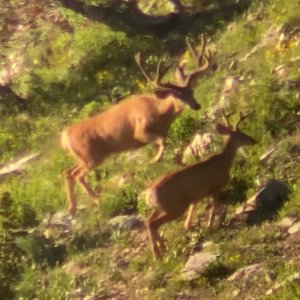
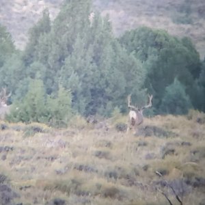
View attachment 149534
View attachment 149535
View attachment 149536
View attachment 149537
View attachment 149538
View attachment 149539
View attachment 149542
View attachment 149544
mozey
Long Time Member
- Messages
- 3,157
That was right next to the Truckee River. I get it too.I appreciate the person who decided to stop and build a house and barn. That's what I would do too.
Homer
Long Time Member
- Messages
- 14,477
Forest service or a piece of private??That was right next to the Truckee River. I get it too.
mozey
Long Time Member
- Messages
- 3,157
Not sure, but it's called Meiss Meadow if that helps.Forest service or a piece of private??
RRCowboyStar
Active Member
- Messages
- 827
Just as your CDT Post, the most positive thing on MM!
2lumpy
Long Time Member
- Messages
- 8,250
Darn right……… good for you. Change is as good as a rest!!I took a few days off trail to go on an Alaskan cruise with my family, but I plan to be back on trail soon.
View attachment 150603View attachment 150604
View attachment 150605
elkassassin
Long Time Member
- Messages
- 38,416
Looks More Like A Small Fishing Boat To Me!
I took a few days off trail to go on an Alaskan cruise with my family, but I plan to be back on trail soon.
View attachment 150603View attachment 150604
View attachment 150605
Burger spot is called “Bugers”…great foodAustria hauf or the burgers spot near the village. I’m gunna guesss there are some good new spots since iv been there.
But your next stop is Tioga pass and despite being a gas station the Mobile restaurant is quite good. The long lost tioga pass resort used to have the best food in a hundred miles but alas is closed
mozey
Long Time Member
- Messages
- 3,157
Halibut was from Juneau, and the sockeyes were from the Kenai near Bings Landing.I might hike that trail if I can go fishing in Alaska.
2lumpy
Long Time Member
- Messages
- 8,250
Don’t Tread On Me

mozey
Long Time Member
- Messages
- 3,157
South Lake Tahoe to I-80. This part of the trail took me through the Desolation Wilderness, Tahoe Rim Trail, and Donner Pass. I normally would not be making a town stop after just 2.5 days and 63 miles. But Desolation Wilderness was the last area on the PCT that requires food to be stored in a bear cannister, and after packing that thing the last 400 miles, I'm anxious to be rid of it and mail it home.


mozey
Long Time Member
- Messages
- 3,157
I-80 to Quincy: The stretch of trail took me by Sierra Butte and through a large burn scar. From what I can gather from my navigation app the fire was three or four years ago, but it's still a fairly hazardous area. There was a lot of negotiating around deadfalls and overgrowth, and I lost the trail a couple times before accidently stumbling onto an old logging road the I was able to follow a couple miles to where it intersected the PCT about three miles before the PCT crossed the Feather River.
With all the deadfalls, I did not feel comfortable about camping in that burn scar, so I hiked the last couple miles with a headlamp to get across the Feather River to an area that was safer to camp. I ended doing 33 miles that day, which is the most I've done on this trail so far.
Over my first week back from the cruise, I hiked 159 miles. Since the Sierras, the trail has flattened out a little, so I hope I can maintain that pace for the next four weeks when I'll be getting off trail again for a dall sheep hunt.
DeerMadness
Long Time Member
- Messages
- 5,588
Nice of you to share. I read every post and look at all the pics with envy and some awe too. What do you think your destination date might be ?
I watched Homemade Wanderlust videos. Still amazed at how She finished many miles in deep fresh snow in running shoes.
I watched Homemade Wanderlust videos. Still amazed at how She finished many miles in deep fresh snow in running shoes.
mozey
Long Time Member
- Messages
- 3,157
I'm hoping to make it into Oregon before getting off trail on August 20. I'll be returning sometime around the last week of September, when I plan to start at the Canada border and come south. If all goes well, I hope to finish Washington before my NM Elk hunt that starts on Oct 19th. Then hopefully I can return and knock out whatever remains of Oregon before my Kansas whitetail hunt in November.Nice of you to share. I read every post and look at all the pics with envy and some awe too. What do you think your destination date might be ?
I watched Homemade Wanderlust videos. Still amazed at how She finished many miles in deep fresh snow in running shoes.
My other problem is I've been notified that jury duty may call, so that may throw a wrench into the mix as well.
Homemade Wanderlust was the one that inspired me to attempt the CDT. So much good stuff in her videos. Another one that I really like (because he's old like me) is Feral Hikes.
mozey
Long Time Member
- Messages
- 3,157
I was about ten minutes too slow on what we think was a record book ram last year. Hopefully he's still around this year and I'll be able to give myself a better opportunity for a shot.Boy this has been a great adventure. Thanks for the pictures and taking us along. You should be in sheep shape by now.
mozey
Long Time Member
- Messages
- 3,157
Awesome--thank you. If you're available then, what I may need is a ride to town. I'm more than happy to pay for gas or buy meals, drinkks, etc, if I don't have to hitch.Good stuff Mozey... if you need anything, yell, your coming up to the Humbug summit, Humboldt summit/ peak area... I'll run it up to you...
Mike
2lumpy
Long Time Member
- Messages
- 8,250
Hope the stars line up Moz…… you’ve earned it.I was about ten minutes too slow on what we think was a record book ram last year. Hopefully he's still around this year and I'll be able to give myself a better opportunity for a shot.
Does the CDT take you onto Rainer or Hood or any of the other majestic peeks, up north?
mozey
Long Time Member
- Messages
- 3,157
Looks like I'll going by all of those.Hope the stars line up Moz…… you’ve earned it.
Does the CDT take you onto Rainer or Hood or any of the other majestic peeks, up north?
2lumpy
Long Time Member
- Messages
- 8,250
Cool. Looking forward to pictures from those.Looks like I'll going by all of those.
mozey
Long Time Member
- Messages
- 3,157
Quincy to Chester. Needed to make a quick stop in Chester to pick up new tips for my trekking poles. I can't thank mod700 (and his dog Grizz) enough for being willing to pick me up at the highway and drive me into Chester (and also for the cold coke).
About 80 percent of this 65-mile stretch of trail was through the Dixie Fire burn scar. It was hot with out much shade, and I found out later that several of my fellow thru hikers are skipping this section. The former Forest Service guy that gave me a ride from Quincy back to the trail told that the Dixie Fire was the single biggest fire in California history.


About 80 percent of this 65-mile stretch of trail was through the Dixie Fire burn scar. It was hot with out much shade, and I found out later that several of my fellow thru hikers are skipping this section. The former Forest Service guy that gave me a ride from Quincy back to the trail told that the Dixie Fire was the single biggest fire in California history.
mozey
Long Time Member
- Messages
- 3,157
Yup. Twice now I've had to hike after daylight hours with a headlamp just trying to find a flat spot that's not near any widowmakers just so I could pitch my tent.Be careful out there. Looks like a lot of widow makers out there.
mod700
Active Member
- Messages
- 385
Pleasure meeting you yesterday!, glad I could help out, though a small amount..you got about 4 miles, then you'll be out of the scar for about another 4 miles, then back into it, for probably several days... that Dixie fire burned over 963,000 acres, for 3 months, it covered some ground. Safe travels Wayne, thanks for taking us along!
Mike
Mike
mozey
Long Time Member
- Messages
- 3,157
It was just as you said.Pleasure meeting you yesterday!, glad I could help out, though a small amount..you got about 4 miles, then you'll be out of the scar for about another 4 miles, then back into it, for probably several days... that Dixie fire burned over 963,000 acres, for 3 months, it covered some ground. Safe travels Wayne, thanks for taking us along!
Mike
mozey
Long Time Member
- Messages
- 3,157
Chester to Burney. This section of trail continues through the Dixie Fire Burn scar and also included the Lassen Volcanic National Park (LVNP) and the Lassen National Forest (LNF). I also saw my first bull elk on this trail, but unfortunately wasn't quick enough with my camera.
The interesting little quirk about this section was that we were required to have a bear cannister if we camped in the LVNP, but not if we hiked all the way through its 19 miles in a single day. Thus, coming out of Chester, it was only about 12 miles to the LVNP boundary, and there ended up being about 12 to 15 of us hikers all camped on the same ridge just about a mile before the boundary.
The other thing going on right now is there has been a breakout of Norovirus amongst the thru hikers, so we're all doing our best to maintain distance from each other. Keeping this mind, I cleared a space in a flat spot that was what I thought was a safe distance from all the other hikers and widowmakers in the area. What I didn't realize was I must have set up too close to a falcon's nest, because that thing immediately started dive-bombing me. I don't know how to describe the sound when those things fly that close over your head, but the closest I can come up with is a cross between an arrow and a jet engine. The first time it happened it came from behind me and I wondered if a bullet had just whizzed over my head. I was spinning around trying to figure out what had just missed me. The second time I saw it coming, but was still surprised that a bird flying would make a sound like that. At that point I should have looked for another place to pitch my tent, but with all the prime/safe spots already taken, I stubbornly finished setting up my tent and crawled in, thinking it would let up as soon as I was in my tent. Wrong again. I'm pretty sure that thing kept it up the whole night, and I don't know if I slept at all. It seemed like every time I was about to fall asleep there would be a loud whoosh followed by its chirp chirp chirp, and I'd be wide awake again.
The next morning I was up before the sun (I'd given up on the hope of getting any sleep). I noticed the hikers that had camped nearest to me were all up too, and I wondered if they were cursing me for camping so close to that bird. I ended up hiking all the way through LVNP that day, plus another 11 miles for a total of 30. LVNP was probably 90 percent burned, but the hot springs, geysers, etc, were still neat to see. However, I didn't see a single bear track or scat that entire day. Seems to me they could relook at the necessity for that rule.
The other complication now is the ongoing Park fire, which is now threatening the areas I just hiked through. The smoke from that fire does not seem to be bothering my lungs, but it sure gives everything an apocalyptic feel. Several hikers behind me have just been evacuated to Burney. I hope they are able to get the fire under control soon, but right now it's not looking good.
2lumpy
Long Time Member
- Messages
- 8,250
Sure looks like the world is still real up there Moz.Chester to Burney. This section of trail continues through the Dixie Fire Burn scar and also included the Lassen Volcanic National Park (LVNP) and the Lassen National Forest (LNF). I also saw my first bull elk on this trail, but unfortunately wasn't quick enough with my camera.
The interesting little quirk about this section was that we were required to have a bear cannister if we camped in the LVNP, but not if we hiked all the way through its 19 miles in a single day. Thus, coming out of Chester, it was only about 12 miles to the LVNP boundary, and there ended up being about 12 to 15 of us hikers all camped on the same ridge just about a mile before the boundary.
The other thing going on right now is there has been a breakout of Norovirus amongst the thru hikers, so we're all doing our best to maintain distance from each other. Keeping this mind, I cleared a space in a flat spot that was what I thought was a safe distance from all the other hikers and widowmakers in the area. What I didn't realize was I must have set up too close to a falcon's nest, because that thing immediately started dive-bombing me. I don't know how to describe the sound when those things fly that close over your head, but the closest I can come up with is a cross between an arrow and a jet engine. The first time it happened it came from behind me and I wondered if a bullet had just whizzed over my head. I was spinning around trying to figure out what had just missed me. The second time I saw it coming, but was still surprised that a bird flying would make a sound like that. At that point I should have looked for another place to pitch my tent, but with all the prime/safe spots already taken, I stubbornly finished setting up my tent and crawled in, thinking it would let up as soon as I was in my tent. Wrong again. I'm pretty sure that thing kept it up the whole night, and I don't know if I slept at all. It seemed like every time I was about to fall asleep there would be a loud whoosh followed by its chirp chirp chirp, and I'd be wide awake again.
The next morning I was up before the sun (I'd given up on the hope of getting any sleep). I noticed the hikers that had camped nearest to me were all up too, and I wondered if they were cursing me for camping so close to that bird. I ended up hiking all the way through LVNP that day, plus another 11 miles for a total of 30. LVNP was probably 90 percent burned, but the hot springs, geysers, etc, were still neat to see. However, I didn't see a single bear track or scat that entire day. Seems to me they could relook at the necessity for that rule.
The other complication now is the ongoing Park fire, which is now threatening the areas I just hiked through. The smoke from that fire does not seem to be bothering my lungs, but it sure gives everything an apocalyptic feel. Several hikers behind me have just been evacuated to Burney. I hope they are able to get the fire under control soon, but right now it's not looking good.
View attachment 152293
View attachment 152294
View attachment 152295
View attachment 152296
View attachment 152297
View attachment 152298
View attachment 152299
View attachment 152300
View attachment 152301
View attachment 152302
eelgrass
Long Time Member
- Messages
- 31,741
It doesn't look like the Park Fire is going to let up anytime soon. Do you have a plan for that?
It's probably just me but I'd have that "Unlawful To Go Beyond This Point" sign in my pack as a souvenir. It looks like a pretty worn trail going right by it. Californians.....
It's probably just me but I'd have that "Unlawful To Go Beyond This Point" sign in my pack as a souvenir. It looks like a pretty worn trail going right by it. Californians.....
mozey
Long Time Member
- Messages
- 3,157
At this point I'm just trying to stay ahead of the fire, but it's close. I had breakfast at JJ's in Old Station yesterday morning just to learn last night that it was placed in the evacuation zone.It doesn't look like the Park Fire is going to let up anytime soon. Do you have a plan for that?
It's probably just me but I'd have that "Unlawful To Go Beyond This Point" sign in my pack as a souvenir. It looks like a pretty worn trail going right by it. Californians.....
The area behind that sign looked like a combination of boiling mud and water to me--didn't need a sign to convince me not to get any closer. But some peoples' kids I guess...