DeerMadness
Long Time Member
- Messages
- 5,502
Would it be tough for a guy that is afraid of heights ? I'm sure I would have too much fear or altitude would make me sick.
This is a tough question, and I can only answer it from my own experience. I too am afraid of heights when it comes to things like sky diving, cliff diving, bungy jumping, or walking out over the Grand Canyon on a glass floor. I avoid those types activities.Would it be tough for a guy that is afraid of heights ? I'm sure I would have too much fear or altitude would make me sick.
I carry a ResMed Air Mini, and I drive it with an Easy Longer 40,000 mA 24 amp charger. A full charge will give me two nights plus recharge my phone, InReach, head lamp, and Skulz. I also carry an ozonic cleaner and clean it at least twice a week.When you have time can you please elaborate on your CPAP machine, batt, and charger. Thx
I'm currently researching if there are any snowless sections of trail north of the Sierras to see if I can do exactly that. I might ruin it for some purists, but all I really care about is a continuous footpath from Mexico to Canada. If I have to leapfrog and then come back to a section, then that's what I need to do.Mos………. Can you drive around the Sierras, continue walking the trail north, then come back and walk the Sierras when the snow’s gone……… and still count it as a successful trip?
There are still a few behind me and to the east. I'm about six miles from Jawbone Canyon road. First time I've had cell service all day.You must be well past the wind machines by now.....getting close to the Skodies?
Yup. I'll have to look at it when I get to it, but odds are I'll take the easiest/shortest route...I see you get a choice of trails above jawbone OHV area.....
")
Yes, but only if I complete this one. If I do, I'll be starting the AT next year.Are you after the AT also ?
 www.advnture.com
Oh man--I'd probably do that if it were for 2024. If I actually complete the PCT this year, I'll most likely be on the Appalachian Trail next year.Hey Mozey, did you see this? Maybe you can swing by the chamber of commerce on your way through and get your name in the hat?
You could be paid $5,000 to hike the Pacific Crest Trail next year – here's how
The deadline for applications is approaching
According to my app, I still have another 50 miles before I'm officially out of the desert.How long before you get into some REAL trees?
Either be in great shape for deer season, or too tired to hunt.If you keep it up you should be done by mid October.

Hopefully it's the first one. Gotta a dall sheep hunt followed by.a rocky mountain goat in September...Either be in great shape for deer season, or too tired to hunt.
What a great adventure!’
That's more like it!
They got stairs in there Moz ?
Actually knocked out 91 since I wrote that...You put that last 50 miles, of desert, behind you Moz. Congrats.
If I see Bigfoot, I'll probably need to have an extra pair of clean shorts in my pack that I can change into (I'll need to burn the old ones). Thanks for the heads up...Mozey, as you know, the key to a safe and rewarding trek is in the preparation. There is still time, but it won't be long and you'll be entering into the Bigfoot zone of northern CA. Only 45% of PCT hikers have a direct encounter so odds are you will be fine. The key is to not panic or show fear and always stand your ground. Best of luck!
All kidding aside, I can't wait until you reach the Trinity Alps and the Marble Mountains, getting close to the Oregon border. My old stomping grounds.If I see Bigfoot, I'll probably need to have an extra pair of clean shorts in my pack that I can change into (I'll need to burn the old ones). Thanks for the heads up...
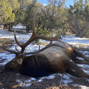
Probably slice off a good loin Moz.Coming off Bishop Pass today was nothing but an ice and snow field. I dropped off the first level and see a crow in the snow not flying away the moment that it saw me. I thought that was weird so I shuffled my way through the snow down to where it was. I got within 15 feet before the crow finally backed away, but it still didn't fly off. Then I saw the antler sticking out of the snow. It was a really nice muley shed. I went to pull it out, but it wouldn't budge. Whoa--there was still a whole mule deer attached to that antler, still frozen in the ice below. I gave it my best effort, but I still could not free it. Just guessing, but I think that thing was pushing 30 inches.
View attachment 148217
View attachment 148218
View attachment 148219
I started back last Tuesday (6/4) after taking two weeks off for the birth of my granddaughter. I just completed Lone Pine to Bishop, which due to still deep snow, raging rivers, and steep passes, were some really hard miles. Incredible country though, and so much eye candy I'm still trying to figure out how to organize the adventure.Great pictures.
Have not noticed any update and thought you may have taken some time off from the hike.
I did not. I wish but if I'm going to finish this thing, I don't feel like I have time. However, one of my fellow hikers, a former Marine, has caught them using his trekking pole, dental floss, and a rooster tail. That makes me want to give it a shot.Did you take a pole?
I wrap fishing line around my water bottle and tape it down. It’s pretty fun to hand line .I did not. I wish but if I'm going to finish this thing, I don't feel like I have time. However, one of my fellow hikers, a former Marine, has caught them using his trekking pole, dental floss, and a rooster tail. That makes me want to give it a shot.
Cottonwood Pass. This was my first day back after two weeks off, and my legs felt like lead, but I still managed 22 miles. Most of the hikers that I started with got off the trail to hike Mount Whitney, and most of the hikers that I finished the day with were all sore from just having completed Mount Whitney. I chose to skip Whitney because I'd hiked it previously. Also, somewhere in this stretch the PCT became one and the same as the John Muir Trail (JMT). Probably my favorite part of the day was seeing a stream that was chalk full of golden trout.View attachment 148237
View attachment 148235
View attachment 148236
View attachment 148238
View attachment 148239
View attachment 148240
View attachment 148241
Uh….it’s national parkWhat's Up With The Weapons Prohibited?
Uh….it’s national park
What Homer said.
I gave my last freeze-dried to a hiker who had run out of food the day before that spent the night on the switch backs leading up to this spot and was not sure he could make it all the way to Bishop that day. But yeah, a steak sounds really good just about any time you're on the trail. But I was only five miles from the trailhead when I found this deer, so I was pretty certain I was going to be eating steak anyway...Hey mozey?
You Shoulda Made A SHED Out Of That Antler & You Coulda Got You A Venison Steak With Alot Of Chipping!
That Meat Would Still Be Good!
Did A Fresh Steak Sound Really Good To You?

Always blows me away at how late those big bucks stay in the high country.
defunct to late! found piles of dead deer on bishop and Paiute pass over the years. I think avalanches get themSometimes Maybe A Little Too Late!
lolDid you eat at the bowling alley?.....best meal in Bishop....
When did you eat there last?
And a camera that only takes blurry photosIf I see Bigfoot, I'll probably need to have an extra pair of clean shorts in my pack that I can change into (I'll need to burn the old ones). Thanks for the heads up...